The famous Ring of Kerry route attracts visitors from all over the world every year. If you travel the Ring in the traditional anti-clockwise direction, the final stretch from Moll’s Gap to Killarney is one of the highlights of the route. It is here that you will find a beautiful area of Killarney National Park known as Derrycunnihy. A small church by the roadside marks the spot from where you can explore the area. Whether it’s a short stroll to stretch the legs, or a jog through some rolling trails or as part of a longer trek through the lakeland paths, there’s something for everyone to enjoy here.
How Do I Get There?
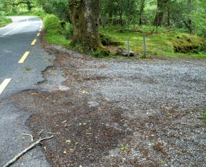
Situated approximately 12km south of Killarney town on the main N71 Kenmare Road, Derrycunnihy Church is located near a bridge that crosses Galway’s river. The trail forms part of the Kerry Way long distance walking route. As is often the case, there are a number of ways to access the trail, but if you’re in a car, there are two places nearby where you can park. The first option is at the car park near the church. An alternative starting / parking point is at a small lay-by on the main N71 about 1km from the church on the Killarney side (see map). If you are parking here, please be careful not to block access.
In this area, there are three great locations to observe the river flowing down into the valley below on its way to meet the Upper Lake. To keep things simple, I’m going to give them each a name:
- The Bridge
- The Cascade
- The Falls
To see the river at ‘The Bridge’, you’ll need to park at the Church car park. The Cascade and the Falls can be reached from either of the starting points. The table below gives an indication of the distances from each to help you plan out the trip.
| Route | Distance | Notes |
| Church to ‘The Bridge’ | 0 km | Be careful crossing the road, watch (& listen) for cyclists |
| Church to ‘Falls’ | 1 km | Short, rough underfoot in places |
| Church to ‘Cascade’ | 1.5km | Rough underfoot in places, riverbank walk |
| Lay-By to ‘Falls/Cascade’ | 1 km | Short, Flat, Child friendly, bike friendly |
| Lay-By to ‘Cascade’ | 1km | Short, Flat, Riverbank with some rough underfoot conditions at end |
| ‘Falls’ to ‘Cascade’ | 500m | Off path trail by riverbank |
| Lay-By to Lord Brandon’s | 3.5km | Undulating, prone to flooding in winter |
| Church to Lord Brandon’s | 4 km | Rough underfoot in places |
Derrycunnihy Church
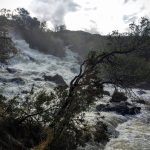
From the church car park, head across the road and look out for the “Kerry Way” sign. Keep an eye (and ear) out for cyclists that may be whizzing past on their way down from Moll’s Gap. Step over towards the bridge for a moment and glance downstream as the river falls over the rocks. After heavy rains, this can be a spectacular sight. Return to the Kerry Way trail and head down the steps and join a little boardwalk. If you are going for a run, be careful on the uneven ground here, especially after a drop of rain. If you are with very small children, this way might be a bit challenging for the little people.
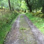
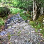 The path meanders its way down through the oak woodlands, crisscrossing some streams along the way. It is mostly downhill and slowly the sounds of the traffic will fade behind you as you go deeper into the woods. As you continue to descend, watch out for some abandoned ruins on your right hand side amidst the woodland. At this point you will join a more substantial gravel based path which is the main trail to Lord Brandon’s Cottage (or the Mass Path as it is also known).
This cross in the path is also a popular spot for deer to come for a drink in the stream so keep an eye open for them in the trees and along by the river.
From here, it’s approximately 3 km to Lord Brandon’s Cottage.
NOTE: During the winter months, the last section of that trail towards Lord Brandon’s Cottage is prone to flooding.
Derrycunnihy Falls
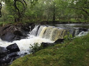 To reach Derrycunnihy Cascade and Falls from this junction, turn right (following the ‘To N71’ sign) and let your ears guide you towards the sound of crashing water. In a few hundred metres, you will arrive at the Falls, nearby to the site of where the Queen’s Cottage was once located. The falls are just before the wooden bridge and you can follow a grassy path by the river to get a wonderful view from the river bank.
Take care here as the grassy riverbank can become quite slippery, especially after some rain.
Although these falls are not to the same scale as Torc Waterfall or even the nearby Tower Wood falls, Derrycunnihy Falls have a charm of their own.
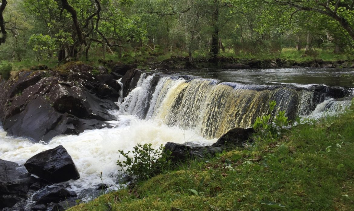
After taking in the Falls, we are now going to head off to find ‘The Cascade’. The scale of the cascade is more impressive and is well worth the little detour off the track to take a closer look.
Derrycunnihy Cascade
 Leaving the falls behind you, cross over the wooden bridge as if you were following the path to the lay-by at the N71. Immediately after you cross the bridge, leave the main path and find a trail along the river bank, heading upstream against the flow of the river. Caution is needed here in wet weather as some of the rocks can become quite slippery. In a few hundred metres you will arrive at the Cascade.
If you are visiting after recent rains, the sounds and spray of the Cascade will dominate the area.
Let’s just say you won’t have too much difficulty finding it! Keep an eye out for red deer in the vicinity as they often frequent here. Other less shy residents include the midges that will greet you in the summer months.
(Another) Queen’s Cottage

Queen’s Cottage 1860s
Another one of the hunting lodges built for the visit of Queen Victoria to Killarney in 1861, the “Queen’s Cottage” was situated right next to the lower falls. Today, no trace of the ruins remain. The banks of the river here provide ample spots for a summer picnic or to just enjoy the falls and the adjoining pools. The path continues on from here to the lay-by that serves as an alternative starting point for the trail. If you are heading back to the church, you need to retrace your steps back along the path and up the trail to your starting point.
Lay-By route
 Although it’s not as easy to find and can be a challenge to park at, the alternative starting point has its attractions nonetheless. It’s a more forgiving surface underfoot (or wheel) and is generally much flatter than the approach from the Church. The trail leads all the way to Lord Brandon’s Cottage and the Gap of Dunloe. However, it’s a much more leisurely spin down to the cascade that lies beneath you in the woodlands.
For the cyclists amongst you it is possible to cycle this route from here although it can be a little bit rough underneath in parts. So if you are worried about your shiny new bike it might not be the best place to go for a spin. A mountain bike would be better suited to some parts of the trail but it can be negotiated on a road or racer bike. Don’t just take my word for it, though, in fact the path was part of the route for one of the stages of the Killarney St. Patrick’s Day Adventure Race.
As you approach the waterfall, the path opens up and a wooden footbridge heralds your arrival to the cascade.
Even if you are not walking the whole way to Lord Brandon’s Cottage, it is worth following this path for at least another kilometre or so beyond the falls. You will be rewarded with some more beautiful lake views as you traverse along the Upper Lake. Rising above the lake, the McGillycuddy Reeks offer a spectacular backdrop. This section is part of the ‘Kerry Way’, a spectacular long-distance trail that winds its way around the Iveragh Peninsula. If you are thinking of covering the full Kerry Way trail, you might want to try using a hiking tour guide company to help with logistics (& lugging the bags around!).
The Eagle’s Rest
I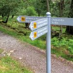 f you do decide to head on to Lord Brandon’s, you can look forward to a nice break on the shores of the Upper Lake. Along with Strickeen mountain, this is also one of the best places to catch a glimpse of the White Tailed Sea Eagles that now live again in Killarney National Park. During the summer months, there is coffee shop serving refreshments. For the well organised and adventurous you can even return to Killarney via boat from here. And for the really adventurous, you can continue on through the Black Valley and the Gap of Dunloe – but that’s a tale for another day….
To get a FREE eBook on Killarney National Park, and to get updates from Killarney Guide, please subscribe with your email below.
Hi.
My lad and I are looking to walk from Kates Cottage to the church via Lord Brandons café . Can you tell me if the cafe is open in February and where I can get hold of a walking map. Is there a public bus service from/passed the church ruins into Killarney.
Hi Tahdy, thanks for leaving a comment.
The cafe in Lord Brandon’s won’t be open in February, it will be probably April/May before it opens again. There is a shuttle bus (killarneyshuttlebus.com) that goes to Derrycunnihy Church but they are not due to be up and running again until March. The best map for walking in the area around the McGillyCuddy Reeks and the Black Valley is the OSI Map Disovery 78 (http://shop.osi.ie/Shop/Products/StockedItemsWH03/PID-51078(StockedItems).aspx). However, if you are walking from Kate Kearney’s to Derrycunnihy, you really don’t need a map. From Kate Kearney’s walk through the Gap and follow the sign for Lord Brandon’s. From there, follow the path along the Kerry Way (marked with the yellow walking man), all the way until you meet the main road near Derrycunnihy Church.
Have a look at https://killarneyguide.ie/gap-of-dunloe-trip/ to find your way to Lord Brandon’s from Kate Kearney’s.
I hope this helps.
Thanks Donal.
Are the gates at Lord Brandon place open all year round, I can’t see any other way across the river if they aren’t.
Hi Tahdy, To the best of my knowledge – they are open all year round but I’m not 100% sure.